Location Mate - Share & Track
- 3.6
- Rating
- 1.00M
- Installs
- Free
- Price
 Analysis by App-foxy
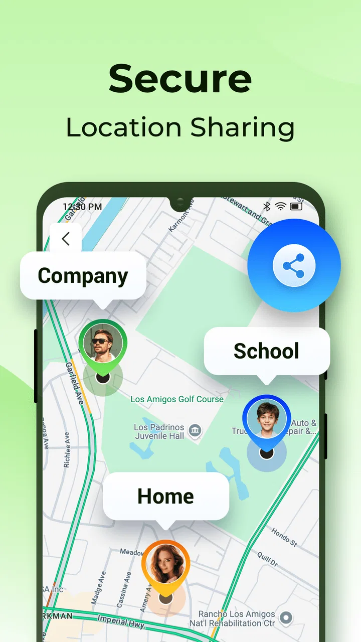
I approached Location Mate - Share & Track as a practical navigation companion rather than another general-purpose map. Its focus is narrower and, in some situations, more useful: planning routes, sharing a location, and creating custom alert zones. That makes it interesting for people who need to coordinate movement with others, not just find a street or business.
After using it in that role, my overall impression is positive but specific. I can see why a free app from IMPACTSOLTER has attracted more than a million installs and an average rating of 4.0 from roughly three thousand six hundred ratings. It gives location-based coordination a clearer purpose than a standard map, especially when several people need to know where someone is or when a particular area matters. At the same time, it is not a complete replacement for a mature navigation service, and its usefulness depends heavily on how comfortable each person is with location tools.
How Location Mate handles readability and navigation
The first thing I noticed is that the app’s central idea is easy to understand. I do not have to guess whether it is mainly for route planning, location sharing, or zone alerts; those three jobs define the experience. That clarity matters for users who find crowded map applications tiring. A conventional map can put directions, traffic, businesses, saved places, transit information, and account features on the same screen. Location Mate feels more purposeful when the task is simply to organize movement and communicate a place.
You May Also Like

 Blood Strike: 2.5 Anniversary
Blood Strike’s Loadouts Turn Every Drop Into a Tactical Gamble
A close look at Blood Strike’s custom loadouts: how fast access to signature weapons reshapes its battle royale rhythm, rewards preparation, and narrows the gap between fights.

 Pandora - Music & Podcasts
Pandora’s Music Is Easy to Start, but Harder to Recover
Pandora’s strength is its low-effort path from a seed to a station. Its weak spot is how much confidence it asks you to place in connection, setup, and quiet recovery.

 8 Ball Pool
 Is Built on Rivalries, Rematches, and Routine
A close look at the rivalries, rematches, shared routines, and unanswered safety questions that turn a quick pool match into a persistent mobile community.

 Samsung Music
’s Quiet Strength Is Playing What You Already Own
Its reach comes less from spectacle than from dependable access to a personal library. That simplicity is both the app’s strongest retention engine and its ceiling.

 AccuWeather: Weather Radar
AccuWeather Review: A Quick, Clear Forecast for Everyday Decisions
For everyday plans, the best forecast is the one you can understand quickly. AccuWeather makes rain timing, radar, and local conditions easy to act on, with a few trade-offs.

 Hill Climb Racing
Why Hill Climb Racing Still Turns Crashes Into One More Run
A tiny car, a bumpy hill and one more upgrade: Hill Climb Racing keeps resurfacing because its simple chaos makes every near-miss feel personal.
More From Our News Desk



For a person who reads screens slowly, the limited scope can reduce mental effort. I would open it with a question such as “Where should we meet?” or “When should I know that someone has entered this area?” rather than browsing through a large collection of map functions. That makes the app a reasonable option for families, small groups, and people who want a straightforward location workflow without learning a full mapping platform.
The route-planning side is most useful when I decide the journey before leaving. I can think through the route, share the relevant location, and use an alert zone as a separate reminder layer. That separation is valuable: the route answers how to travel, while the zone answers when a location-based event matters. Keeping those ideas distinct can make a plan easier to explain to someone who does not enjoy navigating maps.
There is also a practical readability benefit in treating a shared location as the main object rather than burying it inside a long conversation. If I am arranging a pickup, I can focus the discussion on the meeting point instead of repeatedly describing nearby landmarks. This is especially helpful when a friend is unfamiliar with the area or when several people are trying to arrive at the same place from different directions.
Still, I would not call the app automatically simple for every reader. Location tools involve map movement, labels, route choices, and alerts, and those can become visually demanding on a small phone. Someone with low vision may need to adjust the device’s display settings or use the phone’s own accessibility tools to make the interface more comfortable. I found the app’s focused purpose helpful, but users should judge the actual screen presentation on their own device before relying on it for important travel.
A better way to plan a shared journey
My preferred workflow is to create the route first, then decide what information another person genuinely needs. I would share the destination or relevant location rather than sending every detail of my own movement. After that, I would consider whether a custom alert zone adds value. This avoids turning a simple meeting arrangement into a complicated tracking exercise.
A useful example is a relative visiting a medical building, shopping area, or transport interchange. I could prepare the destination, share it with the person who is collecting them, and set a zone around the arrival area. The alert zone is not just a novelty in that situation; it can reduce the need for repeated calls or messages while someone is approaching. It also gives the person waiting a clearer trigger for action.
Another less obvious use is coordinating a group where not everyone travels at the same speed. Instead of asking the slowest person to keep checking messages, the group can agree on a location and use the route plan as a common reference. That can be less stressful for someone who struggles with time pressure, unfamiliar streets, or rapid changes in conversation.
One trade-off is that a shared location can make a plan feel precise even when real life is not. Roads, entrances, crowds, and building layouts may still create confusion. I would always describe the final meeting point in ordinary words as well, especially if the pin could land on a large complex. The app can support the plan, but it should not be the only explanation.
Motor, sensory, and cognitive considerations
Location Mate can be useful for people who want to reduce physical interaction with their phone during a journey. If I prepare a route and location-sharing plan in advance, I have less reason to repeatedly type while walking or traveling. That is a meaningful advantage for anyone with limited dexterity, hand fatigue, tremors, or difficulty performing quick gestures in motion.
The same principle helps users who find rapid visual scanning difficult. A prearranged alert zone can move some of the attention burden away from constantly watching a map. Instead of checking the screen every few minutes, I can rely on the planned location event and concentrate on the surrounding environment. This is particularly sensible near roads, stations, parking areas, or busy public spaces where looking down at a phone creates its own risk.
However, the app should be set up before the demanding part of the journey begins. Creating a route, choosing a shared location, and defining a zone may require several precise interactions. I would not want a user with limited hand control to attempt that while standing in rain, wearing gloves, carrying bags, or moving through a crowded station. The most inclusive workflow is preparation at home, with enough time to check every selection calmly.
For users with sensory sensitivities, the value of a location alert depends on how the phone communicates it. The app’s role is to create the alert zone, while the phone handles much of the notification experience. That means the final result may depend on the device’s sound, vibration, and visual notification settings. Someone who is sensitive to sudden sounds could prefer a quieter notification arrangement, while someone who does not hear alerts may need a strong visual or vibration setting on the phone.
I also see a cognitive benefit in using custom zones as reminders rather than relying on memory. A person who becomes overwhelmed by multi-step travel can divide a journey into meaningful points: leaving home, reaching a station, arriving near a destination, or entering a meeting area. That does not make the route itself easier, but it can make the plan easier to follow. The app is at its best when it reduces the number of decisions a person must make at the exact moment they are traveling.
There is a caution here for users who are prone to notification overload. Creating too many zones could turn a helpful aid into a stream of interruptions. I would begin with one important zone, test whether it is useful, and only then add another. A small number of carefully chosen alerts is more manageable than marking every stage of a trip.
Where it helps people traveling together
Location sharing can support different communication styles. One person may prefer a map, another may prefer a short message, and a third may need a clear event such as “the person has reached the area.” By combining route planning with a shared location and a custom zone, the app can give each participant a more concrete reference point.
For a caregiver or family member, that can make coordination less dependent on repeated phone calls. For a user who finds phone conversations difficult, a prepared location may communicate more effectively than explaining directions verbally. For someone who is anxious in unfamiliar places, knowing that another person can follow the agreed plan may provide reassurance without requiring constant contact.
Even so, I would discuss the arrangement with everyone involved first. Location sharing works best when the purpose and duration are clear. The app can help coordinate people, but it should not replace consent, trust, or a backup communication method. If a journey is important, I would still make sure the group knows how to contact one another if the plan changes.
Situational access in everyday use
The strongest case for this app appears in situations where timing and location are connected. Imagine I am collecting a friend from a large venue. Rather than asking them to identify an exact curb or repeatedly send updates, I can organize the destination and define an alert area around the pickup point. When the person reaches that area, I have a clearer reason to prepare. The arrangement is not perfect for every venue, but it is more practical than relying on vague messages such as “I am nearly there.”
A similar workflow could help a household coordinate school, errands, or appointments. One person can plan the route, another can receive the location, and a zone can mark the point where the next step should begin. The benefit is not sophisticated navigation; it is reducing uncertainty between people who are moving separately.
For older adults, the app may be useful when a family member wants a simple shared destination rather than a complicated set of directions. I would keep the plan short and use familiar landmarks alongside the digital location. If the person is uncomfortable with maps, another family member should prepare the route and explain what the alert means in plain language.
For users with mobility limitations, route planning can be valuable before leaving, but I would be careful not to assume that the shortest route is the easiest route. A map-based route may still include stairs, steep ground, difficult crossings, or entrances that are awkward to access. Location Mate should therefore be treated as a coordination tool, not as proof that a route meets a person’s mobility needs. I would verify the physical environment separately whenever accessibility is important.
For people traveling in noisy places, sharing a location may be more dependable than trying to hear spoken instructions. A person at a festival, station, or busy shopping center can work from a common point on the map. Yet crowded environments can also make precise positioning difficult, so I would pair the digital plan with a visible landmark or a clearly described entrance.
The app is also suitable for users who want to create a repeatable routine. A regular trip can benefit from a consistent destination and a familiar alert area. The non-obvious advantage is that the routine can be communicated in advance, so the person traveling does not need to negotiate every detail while already under pressure. That is a small design choice in practice, but it can make a noticeable difference for someone who needs predictable steps.
How it compares with ordinary map apps
I would choose a general map service when I need extensive place search, detailed local information, live travel options, or a broad navigation ecosystem. Those tools are usually better for exploring an unfamiliar city or deciding between many types of transport. Location Mate makes more sense when the main problem is coordinating people around places and arrival events.
Compared with sending a location through a messaging app, it offers a more deliberate route-and-zone workflow. Messaging is quicker for a one-off pin, but it can become messy when a group needs a planned route or a location-based alert. On the other hand, a messaging app may be more familiar to everyone involved, which can outweigh the extra structure here.
Compared with a dedicated family tracking service, this app’s appeal is its focused planning concept. I would not select it solely because I want a broad monitoring system. I would select it when route preparation, location sharing, and custom zones are the specific tasks I need. That distinction matters for privacy-conscious users who prefer not to introduce a more expansive tracking product than the situation requires.
The free price makes trying it straightforward, while optional in-app purchases range from $2.99 to $12.99 per item. I would begin with the free experience and decide based on actual use rather than assuming paid options are necessary. The app is rated for Everyone, which makes it approachable for a broad audience, but an age label does not remove the need to explain location sharing to children or anyone who may not fully understand what is being shared.
Remaining barriers and practical cautions
The biggest barrier is not the basic idea; it is the responsibility placed on the person configuring the plan. A wrong destination, an overly broad zone, or a misunderstood alert can create false confidence. I would review the route and zone before sharing them, especially when another person depends on the information.
There is also a learning curve for users who do not regularly work with maps. Even a focused app still asks people to understand pins, areas, and movement. A friend or family member may need to demonstrate the workflow once. I would create a simple test plan in a familiar place before using the app for an appointment, pickup, or unfamiliar journey.
Users with visual, hearing, motor, or cognitive disabilities may experience the same feature differently. A visual alert is not enough for someone who cannot see it easily; a sound is not enough for someone who cannot hear it; and a complex setup is not enough for someone who needs fewer steps. The most reliable approach is to combine the app with the phone’s preferred notification and display settings, then test the result under realistic conditions.
Another limitation is that the app cannot solve every physical or environmental problem. A location pin does not describe a curb, lift, entrance, lighting condition, pavement surface, or crowd density. If those details affect safe travel, I would use additional local knowledge and confirm the destination with the person who will actually arrive there.
I would also avoid treating an alert as a guarantee that someone is ready to meet. Reaching a zone may mean entering a broad area, not standing at the precise doorway. In my view, the best practice is to use the alert as a prompt to check in, not as permission to stop communicating altogether.
The app is available for devices running Android 7.0 or later, and its current version is 1.0.40. That makes device compatibility an important first check for anyone using an older phone. I would also install and configure it before an important trip, rather than discovering compatibility or usability issues at the last minute.
My inclusive verdict
Location Mate - Share & Track is a worthwhile choice when location coordination is the real need. I like its combination of route planning, shared places, and custom alert zones because those functions address a practical problem that ordinary maps and casual messages do not always handle elegantly. For families, caregivers, friends arranging pickups, and users who benefit from predictable travel steps, it can make movement easier to organize.
Its accessibility value comes mainly from reducing repeated checking and simplifying communication around a place. Preparing a plan in advance can help people with limited dexterity, sensory differences, anxiety, memory challenges, or difficulty processing rapid instructions. The strongest tip I can offer is to create one clear route, one meaningful shared location, and only the alert zones that genuinely reduce stress. That keeps the app supportive instead of overwhelming.
I would skip it if I wanted a full replacement for a major navigation platform, extensive place discovery, or a complete solution for physical route accessibility. I would also be cautious if the people involved are uncomfortable with location sharing or are unlikely to learn the setup. In those cases, a familiar messaging tool or a conventional map may be easier, even if it offers fewer coordination features.
Developed by IMPACTSOLTER, the app has reached a substantial audience while remaining free to start, with optional purchases available inside it. My final view is that its value lies less in replacing other map apps and more in filling a specific gap between navigation and communication. If you need a calmer, more structured way to plan where people should go and when a location matters, it is worth trying. Just treat its alerts as helpful prompts, verify routes for real-world access needs, and keep a simple human backup for important journeys.
FAQs for Location Mate - Share & Track
01What is Location Mate - Share & Track, and how does it work?
Location Mate - Share & Track is a user-friendly app designed to help you share your real-time location with friends and family. It utilizes GPS technology to provide accurate location data, allowing users to track each other's whereabouts on a map. This is particularly useful for coordinating meet-ups or ensuring safety during travels.
02Is my privacy protected while using Location Mate?
Yes, Location Mate prioritizes user privacy. The app offers customizable privacy settings allowing you to choose who can see your location and when. You can share your location only with selected contacts and set time limits for how long your location is visible, ensuring your data is secure and shared only with trusted individuals.
03Does Location Mate drain my phone’s battery quickly?
While any app using GPS can affect battery life, Location Mate is optimized to minimize battery consumption. It uses advanced algorithms to update your location efficiently. However, it’s recommended to have a charger handy if you plan to use the app extensively over long periods, especially during travel.
04Can I use Location Mate without an internet connection?
Location Mate requires an internet connection for real-time location sharing and tracking. However, it can store location data offline and update it once you reconnect to the internet. This feature ensures your location data is as accurate as possible, even in areas with limited connectivity.
05Is Location Mate free to use?
Location Mate offers a free version with basic features suitable for most users. However, there is a premium version available that provides additional features such as enhanced location accuracy, ad-free experience, and priority customer support. The premium version is available through a subscription model, providing more robust functionality.
Pros
- Easy-to-use interface for quick access.
- Real-time location sharing with friends.
- Battery-efficient tracking feature.
- Customizable privacy settings for users.
- Offline maps available for remote areas.
Cons
- In-app ads can be intrusive at times.
- Limited features in the free version.
- Requires constant internet for updates.
- Occasional delays in location updates.
- High data usage when tracking in HD.

Location Mate - Share & Track
Gallery